TerraColor NextGen Imagery
TerraColor NextGen is a seamless, true color satellite imagery map of the entire planet sampled at a spatial resolution of 15 meters-per-pixel. We strive for a realistic "earth from space" look that includes important information about ocean features such coral reefs, sandbars, and river deltas that are key to understanding the true character of our world. The product is created from 1000's of Landsat satellite scenes that have been carefully processed and color balanced to provide a very high level of finish. NextGen offers an up-to-date medium resolution base map of the entire globe, and provides a perfect complement to high resolution imagery by delivering a consistent, regional view of larger areas. For more detailed information, visit our Specifications or FAQ pages.
"For those who have seen the earth from space, and for the hundreds perhaps
thousands more who will, the experience most certainly changes your perspective.
The things that we share in our world are far more valuable than those which
divide us."
- Donald Williams, US astronaut
![]() 100% True Color - Processed using satellite bands corresponding to the same wavelengths of light to which the human eye is sensitive (called "true color"), NextGen provides truly realistic views of the earth. In contrast to other products created with artificial colors, NextGen provides an excellent color match to high resolution true color imagery base maps.
100% True Color - Processed using satellite bands corresponding to the same wavelengths of light to which the human eye is sensitive (called "true color"), NextGen provides truly realistic views of the earth. In contrast to other products created with artificial colors, NextGen provides an excellent color match to high resolution true color imagery base maps.
![]() Nearly Cloud-Free - With less than 0.5% cloud cover globally, NextGen offers clear, haze-free views of the earth. We have worked hard to reduce clouds and atmospheric haze, even in difficult areas with chronic cloud cover such as equatorial tropical rain forests, Alaska's Aleutian Islands and the southern tip of South America.
Nearly Cloud-Free - With less than 0.5% cloud cover globally, NextGen offers clear, haze-free views of the earth. We have worked hard to reduce clouds and atmospheric haze, even in difficult areas with chronic cloud cover such as equatorial tropical rain forests, Alaska's Aleutian Islands and the southern tip of South America.
![]() 15-Meter Resolution - NextGen's spatial resolution of 15 meters per pixel is perfect for viewing the earth from global scales all the way down to 1:60,00 map scale. You can clearly see land use, urbanized areas, freeways, agricultural areas, rivers, coral reefs, and much more.
15-Meter Resolution - NextGen's spatial resolution of 15 meters per pixel is perfect for viewing the earth from global scales all the way down to 1:60,00 map scale. You can clearly see land use, urbanized areas, freeways, agricultural areas, rivers, coral reefs, and much more.
![]() Seamless and Consistent - We have carefully mosaicked and color balanced 1000's of Landsat 8 images to create a seamless view of the entire planet. We have also optimized the image contrast globally to maximize information content and make features easier to distinguish.
Seamless and Consistent - We have carefully mosaicked and color balanced 1000's of Landsat 8 images to create a seamless view of the entire planet. We have also optimized the image contrast globally to maximize information content and make features easier to distinguish.
![]() Ready to Use - Using our proprietary variable-density ocean mask, we remove clouds, ice and image edges from ocean areas to provide a clean, finished map-like look. The imagery is ready to use off-the-shelf for any application and requires no additional work or editing.
Ready to Use - Using our proprietary variable-density ocean mask, we remove clouds, ice and image edges from ocean areas to provide a clean, finished map-like look. The imagery is ready to use off-the-shelf for any application and requires no additional work or editing.
![]() Customizable - We can customize NextGen to meet nearly any requirement, from custom bathymetric ocean fills to brightness adjustments to different map projections. Contact us with your requirements - we can often customize the imagery at no additional charge.
Customizable - We can customize NextGen to meet nearly any requirement, from custom bathymetric ocean fills to brightness adjustments to different map projections. Contact us with your requirements - we can often customize the imagery at no additional charge.
Slide to view the NextGen global coverage with different types of ocean fill
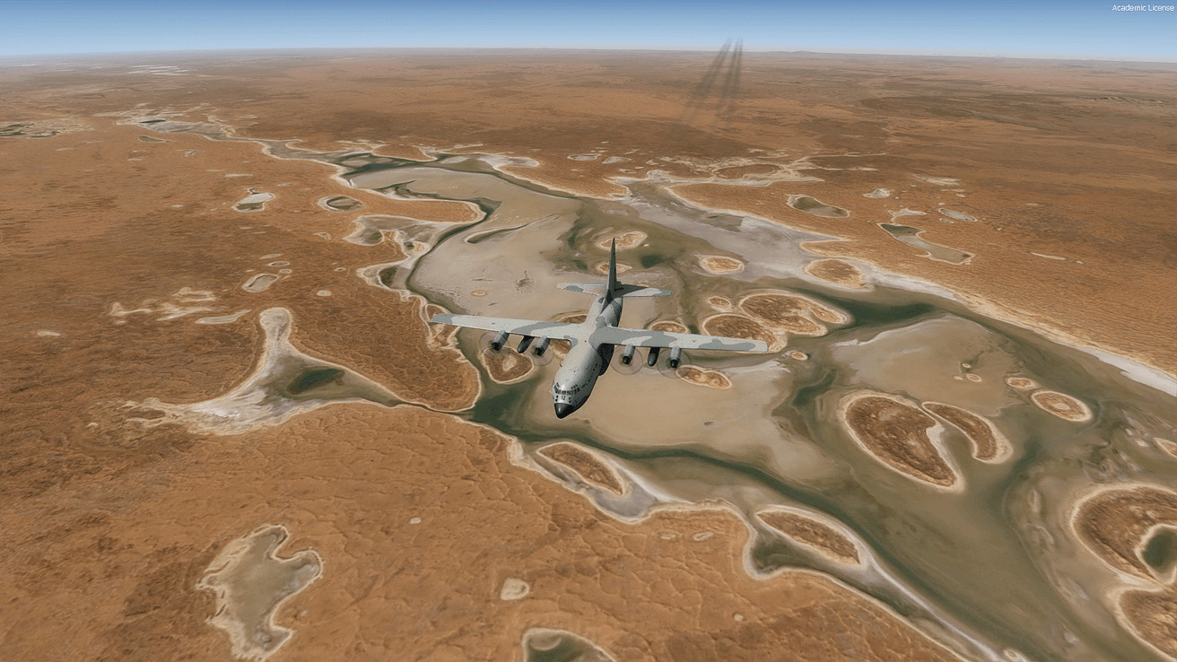
Flight simulator image using NextGen imagery of Northern Territory, Australia
(courtesy Gibson Sceneries)


Earthstar Geographics LLC
San Diego, California, USA
Global Satellite Imagery Solutions
Started in 1995, Earthstar Geographics offers a wide range of experience and expertise in satellite remote sensing and related technologies. We are a leading content provider for the global geospatial data market, with an extensive international client base. We are proud to offer reduced pricing to qualified educational and non-profit clients.